Web Mapping Solutions
Our working Framework
-
ArcGIS Online
-
R Shiny DashBoard
-
LeafletJS
-
Open Layers
-
Map Box
-
Google Mapping API
-
Turf JS
Services we provide
-Operational Dashboard
-Monitoring Dashboard
-Adding custom data layers
-Integrating with other data sources
-Creating customized map styles
-Data hosting, data analytics
-Supporting for creating location-based mobile applications
Project Name: GTCL Pipeline Survey and GIS Preparation
Purpose of Dashboard: Real time GIS data monitoring
Dashboard Tools: Open-source platform (R shiny)
Project Name: Geospatial Dashboard District Development and Growth Priorities (DDGP) Cox’s Bazar, Bangladesh, UNDP
Purpose of Dashboard: To show the development status of Cox’s Bazar district
Dashboard Tools:
- ArcMap
- MS Excel
- Rstudio
Data Storage Platform: Shinnyapp.io
Project Name: UKAID Livelihoods and DRR Project of Barishal City Corporation, BRC
Purpose of Making Dashboard: to support the project team to capture and monitoring data from the field. (Monitoring Dashboard)
Dashboard Tools: Open-source platform (R shiny)
Project Name: Rural Renewable Energy Project (RREP), Sierra Leone: WP6 Matching Grant
Purpose of Making Dashboard: to improve and promote productive use in mini-grid
Map view includes-
- Grantee
- Grant Amount
- Sector
- Beneficiaries
- New jobs
Desktop GIS Mapping Solution
For all of your Geographic Information Systems (GIS) needs, our team of experts is here to help. From straightforward mapping projects to complex geodatabase design and application development, we have the internal expertise to support you in sharing information in ways you didn’t know were possible.
Services we provide
– Digitizing
-Georeferencing
-Drone image georeferencing
-Spatial Analysis
-2D/3D GIS Modeling
-Geodatabase Design & Creation
-Data Conversion
-LiDAR Conversion
-Data Migration
-Program Development
-Web Based GIS Mapping
-Programming
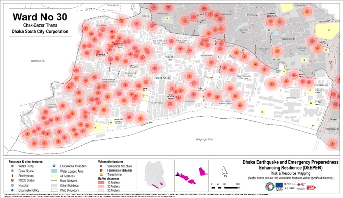
Dhaka Earthquake and Emergency Preparedness Enhancing Resilience (DEEPER)
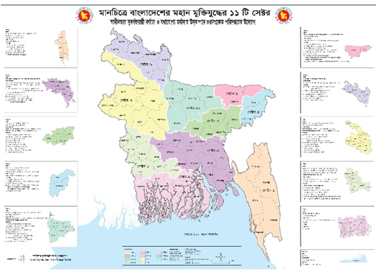
GIS Mapping of 11 Sectors and Genocide Site of the Bangladesh Liberation War
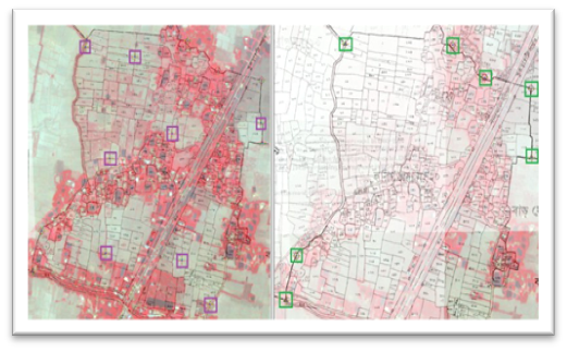
Georeferencing of Mouza Maps of 15 Polders at Coastal Area of Bangladesh using Satellite Imageries
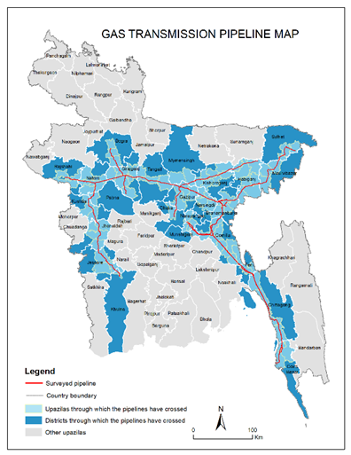
GTCL Pipeline Survey and GIS Preparation
RS Mapping Solutions
Services we provide
– Land Use Land Cover (LULC) Mapping
– Weather Forecasting
– Environmental Study
– Study of Natural hazards
– Resource exploration
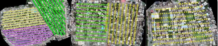
Geolocation mapping of captured high-resolution images for different flight plans
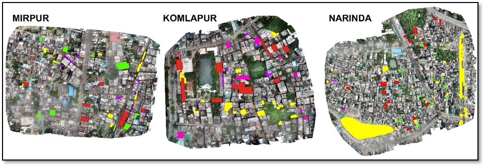
Identified solid waste disposal sites in Mirpur, Komlapur, and Narindaa
Digital Survey and 3D modeling for Jail Khal in Barisal City Corporation